Climbing Stetind

Dean Russell • November 6, 2018

Climbing Stetind - Norway's National Mountain

In spring last year I was having a beer with a friend, fellow climber and one of Bristol’s up and coming photographers, James Austrums. Our conversation during the evening led to our shared experiences living in Norway , the beautiful rugged mountain landscapes, views that deserve an Instagram post with a #photooftheday tag and the mystical Auroua Borealis know as the northern lights. James had spent a lot of time exploring the North of Norway and passionately described a granite mountain rising from the fjords that can only be described as iconic. A couple of hours later, a couple more pints, much trawling through photos on google and flights were swiftly booked that would take me to the artic circle to climb Stetind, Norway’s national mountain.

Fast forward 6 months and our objective to climb the South Pillar was chosen, through James we had Favre-Leuba, a Swiss watch company onboard and so many locations that were hand picked to ensure we got the best chance of seeing the northern lights. Just a week before our flights, the plans we had made looked to need serious reconsideration. Numerous weather systems were predicted to push over Norway bringing extensive cloud cover, blocking views of the sky and rain that would prevent any attempt on a large mountain route. As we dropped under the clouds descending into Bødo rain was pounding the plane and spirits were a little bit dampened by the prospect of 10 days searching for alternative objectives that would fit our brief. Our attention was soon distracted though as we rushed to get to the shops before they closed for the weekend. Being in a wet tent is one thing but being hungry in a wet tent isn't worth thinking considering.

After a couple of days battling the elements and getting out walking in the beautiful mountains of Lofoten, a late night weather check confirmed a change ahead. I was trying not to get excited, I've been here before looking at weather reports from all over the internet until I found one I liked the sound of only for it to change again! A short drive, many tunnels that are synonymous with the Norwegian mountains, a quick couple of ferries, a night sleeping in the back of the hire car, more tunnels and we finally got sight of our objective for the first time. The mountain itself consists of only one rock formation that gets progressively steeper and steeper as you near the summit and with only a small splattering of clouds and endless blue skies it deserved being stared at in wonder.

After checking our kit and finishing packing we started walking up though extensive birch forest that eventually led into open country and spectacular views. After a number of hours the ground started to steepen and we ascended through boulders that had been pushed down the valley by a glacier that has long since receeded before reaching Svartvatnet, an iced lake, that would be our bivi spot for the night. That nights sunset produced amazing colours behind the mountains and emphasised once again why I have pursued climbing mountains for so many years, I slept happy knowing what the morning would bring.

It was an early start and only a short hour walk before arriving at Kongelosjen (Kings Box). I started to place the gear on my harness the same way I always place it before a route, part ritual, part superstition, tracing out the route ahead in my mind. We made good progress at the base of the mountain, getting into a good rhythm of movement over the perfect granite cracks, grooves and slabs. The weather couldn’t have been better for the ascent , very little wind with the sun wrapping us in warmth at the belays, allowing us to enjoy the views that got better the higher we ascended. These first pitches were a good warm up to the upper reaches of the mountain that would get progressively harder.

Climbing can be meditative, having a clear mind thinking about nothing but the moves you make and the gear you place. Its usually a sign that I’m climbing confidently and it was good to have that clearness of thought as I moved. The first difficulties were encountered after 9 pitches where a recent large rockfall had left behind a thin exposed finger crack. The moves were sustained throughout and the sole thin crack was being used for fingers, toes and gear which was fiddly at the best of times, it was good to climb uninhibited in such a spectacular setting.

The next 120 metres of climbing were by far the best and the most difficult. The route climbed a 40 meter pillar with grooves allowing good bridging throughout and the crux pitch which was a beautiful right slanting grove. For much of the climb we had been climbing cracks that you could wedge feet, hands, even arms into. All of a sudden, as is the case with climbing, a switch to a completely different style was needed.

Focused intently on the granite in front of me searching for anything that would assist with my footwork, any depressions or dimples anything that would help as I climbed, but nothing. After arranging a couple pieces of gear, I started through the crux and smeared, balanced and delicately made my way up the pitch with a breathtaking exposed drop down to the start of the route and beyond. The journey now to the top was straightforward and a slight sigh of relief that the crux so close to the top hadn't caused us any problems.

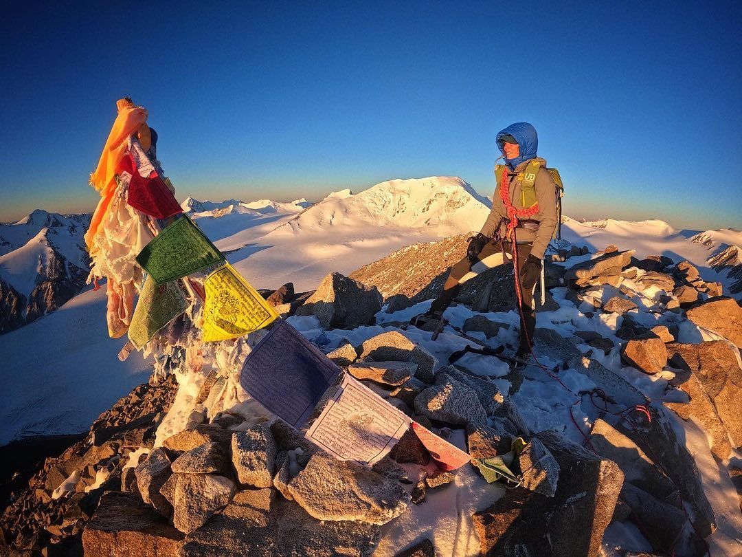
Standing on the summit of Stetind with the sun dropping to the west, the views over to Loftoten and the many mountains were out of this world. I found myself looking intently at the different mountains and thinking the same thought that I always think after climbing a route...... whats next! Descending along the normal route (which is a rock climb in its own right) and down to the tent we swiftly packed up and continued down in the fading light. We camped that night with a fire under the stars with Stetind in the backdrop enjoying a celebratory beer. As if the day couldn't get any better but then a a vivid display of the Northen Lights, Norway really is one of the most beautiful countries on earth!


Dean Russell is a climber, mountaineer and trail runner with over 15 years experience who offers courses and experiences to make your very own adventure happen. If you are interested in what Adventure Awaits offers you can find more information here .

James Austrums is a Bristol based photographer and videographer working in the outdoor adventure industry. James has been working for Favre-Leuba, using his unique adventures to promote their range of watches of which this was one. You can find more details at www.jamesaustrums.com

Running up a hill
By Dean Russell January 8, 2025
Fuelling before and during the race to help you perform at your best.
By Dean Russell May 14, 2024
Hints and tips to enhance your technical running
By Dean Russell January 1, 2024
Embrace the chill and discover a whole new satisfaction in your runs
By Dean Russell October 5, 2023
How to ensure you have the best chance to complete this demanding and exhilarating hike.
By Dean Russell January 13, 2023
“There is no reward without risk, I can’t imagine living without it” - Blaine Smith
Top runs in north wales; top runs in Snowdonia; running guiding; running snowdonia, sn
By Dean Russell November 7, 2020
Second in a new series highlighting the finest running routes around Snowdonia's national park. In the second blog post the author, Dean Russell, showcases a short remote feeling run that packs a punch with a horseshoe run around the Northen mountains of the Carneddau.
By Dean Russell July 27, 2020
Many of us found ourselves with more time on our hands as lockdown and travel restrictions took grip and the country battled to contain the Coronavirus pandemic that spread across the world. Much of the National Park in Snowdonia closed to ensure there were no undue pressures on local emergency and rescue services and the beloved mountains were off limits for the time being. Running through lockdown was a good opportunity to gain an intimate knowledge of all the footpaths in the local area, often running through thickets of brambles and gorse on paths that had been long since forgotten. Living on the edge of Snowdonia National Park at the outlet of the glacially formed Llyn Padarn, many of my lockdown routes passed a brass plinth that speaks of the evolution of the scenery in front of your eyes. Many of my hours passed enjoying the mountains, reflecting so perfectly on the lake when the air was still, watching how the light morphed high up as the sun started setting on another day of lockdown. It was on one of these many nights that I started to trace the line of the skyline and imagined running a route from the end of the lake across all the mountain tops around Llyn Padarn. As many people delved into cookbooks, looking for the next bake, or updating general knowledge preparing for the next zoom quiz, I hunched over my kitchen table with the map of Snowdonia laid out tracing the same line I had envisioned earlier. What I had been tracing was the hydrological water catchment for Llyn Padarn, twelve peaks where rain drops run from its summits onto their rocky slopes, down steep runnels into streams and rivers feeding the lake, flowing right to the outlet where I had been admiring one of the best views in the National Park. With the levels of Coronavirus infections reducing, on another unusually fine Friday afternoon the news from the Welsh Government I had been waiting for was delivered in their regular briefing. The mountains were going to open in their entirety and it felt fitting to commemorate the opening by running the skyline that I had so often admired. To follow the water catchment the route first ascends gently on roads through the villages of Fachwen and Dinorwic and into the local quarries. Described by some as a blight on the landscape, the sometimes otherworldly looking vistas are a reminder of the industrial era when North Wales was home to one of the most important slate producing areas. Ascending through endless slate piles, up inclines, past buildings and metal work that once would of been integral to the workings you get a great sense of how hard and dangerous the work for the miners must have been. After leaving the quarries behind, already high in mountain terrain, the summit of Elidir Fach was soon under my feet. A further short pull brought the rocky summit of Elidir Fawr, with its jagged grey gritstone that is in contrast to the red sedimentary siltstone on the flanks leading to the summit. The hard work initially getting up high was rewarded heading along the spectacular ridge to Mynydd Perfedd and sublime views to Marchlyn Mawr reservoir, Ogwen valley and one of North Wales most iconic mountains, Tryfan. The position of the Glyderau with mountain ranges on either side gave a big mountain feel to the summits of Foel-goch and Y Garn before descending towards Twll Ddu, more commonly known as Devils Kitchen named due to the sinister plume of smoke rising from a huge crack in its cliffs. Instead of descending into the depths of the cauldron a steep ascent up scree slopes of Glyder Fawr was necessary which felt like traveling without moving as my feet slid from underneath me. Descent from the summit was via the red route that winds its way south through complex terrain passing boulders with a faint spray painted red dot leading the way. The views across the valley to the classically shaped Crib Goch were spectacular and left me in no doubt that the next section contains some of the best scrambling terrain in North Wales. Pen Y Pass was a welcome respite and a chance to grab a snack and recharge my batteries before the crux of the run. The going got tough as I made my way up from Pen y Pass with the technical, engaging scramble up the initially broad East ridge that converges to an airy ridge walk up to Crib Goch’s summit. The fun didn’t stop there though continuing along the summit ridge which has some spectacular positions where it is not uncommon to see people traversing it “Au Cheval” (like a horse) before yet more first class scrambling to reach the grassy summit of Crib y Ddysgl. The way forward was made up of skirting impressive Cwms that are the product of scouring in the late Ice Age that ended some 10,000 years ago. The geology of the Cwms are synonymous with glacial activity in Snowdonia with the mountains having two distinct faces, grassy slopes facing South-West and steep craggy ones facing North-East. After completing the technical section where my thoughts were solely on the next foothold and handhold as you traverse a couple of Snowdon’s giants its a welcome respite, even with tired legs, to run up and down the grassy summits of Moel Cynghorion, Foel Goch, Foel Gron and Moel Eilio. Appreciating the great views of the Nantlle valley and the Menai Straits, I found myself in a state with no thoughts running through my mind, no stresses, no to do lists, nothing. Running has long been associated with controlling stress and boosting the bodies ability to deal with mental tension. Combining that with the benefits of being in the mountains has long been vital to my own mental wellbeing and as I continued my run I could feel the mountains cleansing my mind with every step, oh how I had missed the mountains. Running down from Moel Eilio skirting another set of slate quarries the final summit of Cefn Du was soon arrived at with the sudden realisation that there are no well worn paths from its summit and so a degree of heather bashing was required. Following a faint path by a dry stone wall led to a better trodden path that drops down eventually to the main road and a short run back to the plinth where the journey had started. An opportunity to admire the views, a chance to reflect, taking in all the mountains that have been traversed and ponder there long evolution just as the words by Gillian Clarke describes: But for how long? Cherish these mountains, born in fire and ash out of the sea to make this wilderness, Asleep for aeons beneath ice and snow, carved by the shifting glaciers long ago, Till ten millennia back, the last ice age made right for fern and purple saxifrage, This place, whose evolutions given birth to the rare Snowdon lilly’s home on earth, But all could go with the melting snow. The Llyn Padarn Skyline is a 36 km run with 3,108m of height gain that was completed on the 6th July 2020 in 6 hrs 31mins and 25 secs. If you would like to have a go at the Skyline there are more details on how you can get your time recorded here . Dean Russell is an active trail runner, climber, mountaineer and trekker with over 16 years experience in the mountains. Usually found running and climbing in his local mountains in North Wales he offers private and group guiding highlighting the best routes in Snowdonia’s national park. If you would like further details then you can contact Dean here .
Top runs in north wales; top runs in Snowdonia; running guiding; running snowdonia, snowdon runs
By Dean Russell June 19, 2020
First in a new series highlighting the finest running routes around Snowdonia's national park. In the first blog post the author, Dean Russell, showcases a run with some of the best views in the local area with a horseshoe run around Moel Eilio.
Running shoes, running adventures, running in north wales
By Dean Russell March 31, 2020
Blog for those addicted to running with tips and ideas to help get them through the Coronavirus lockdown
Multi Day Running Trail Running Multi day events
By Dean Russell January 14, 2020
Run some of the UK's long distance trails or traverse a mountain range in the Alps over multiple days for a new adventure in 2020 - here's some top tips on how.
More Posts