
Moel Siabod SE Ridge
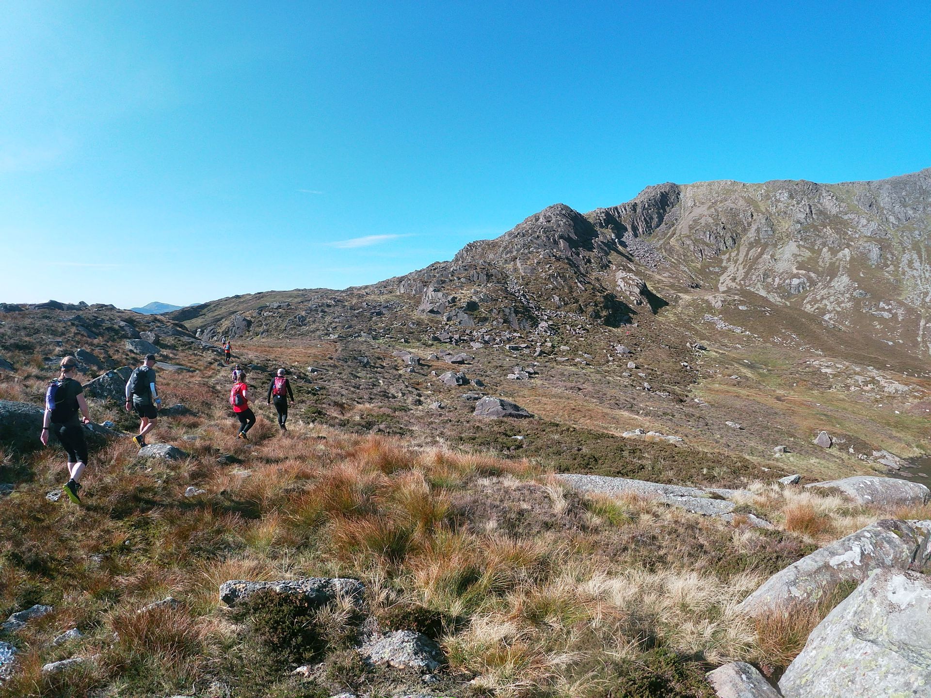
The South East ridge know locally as Daear Dhu is a classic route up Moel Siabod that shows the mountain in all its glory. The rocky sections are always safe with very little exposure and a great first introduction to skyrunning.
Overview of the Run
Moel Siabod is a lonely mountain, seeing less visitors, compared to some of the others in Snowdonia but don’t let that put you off. The route sticks close to a well worn path so you can dip in and out of the technical sections to your hearts content. Make sure you take time at the summit to enjoy views over the whole of the Snowdon horseshoe in all its glory.
13.2km (8.2miles)
760m
Moderate / 1-
Approach
The S2 - Snowdon Sherpa bus leaves from multiple stops in Llanberis is by far the easiest way to access Capel Curig Bryn -Llys.
Capel Curig can be accessed by car from Llanberis on the A4086 over Llanberis pass turning left at the Pen-y-Gwryd Hotel signposted for Capel Curig on the A498. After passing the Plas y Brenin National Mountain Centre turn right onto the A5 towards Betws-y-coed and drive 2km to signposted parking at Bryn Glô. There is additional parking behind Joe Browns outdoor shop in Capel Curig accessed via a lane next to the shop.
By the car park Bryn Glô has a cafe and pizzeria or back towards Capel Curig there is Moel Siabod cafe. Public toilets and Joe Browns outdoor store are all located at the junction between the A498 and the A5.
Route Description
1.
From Bryn Glô car park cross the road and head towards Capel Curig for 200m before crossing the bridge over Afon Llugwy. Follow the road for 500m before taking the footpath signposted track (right) leading up into the forest . Climb over a stile and follow the track for 2 km’s steeply winding its way initially through the forest before leading to open moorland and fine views of Moel Siabod and its South East ridge that dominates the skyline.
2.
The track contours around Moel Siabod and enters a coniferous forest with a gate at its entrance. Take the second track on the right, around 200m from the gate and follow this to the T-juction at its end. Head North (right) at the junction for 300m where the track ends in a clearing, a bridge over a stream to the East leads to a well defined path through scrubland. The path roughly follows the left hand side of the stream running past a fence up a hill and over a stile. When the path meanders close to the stream and the waterfall is visible cross over the stream with care and ascend steeply on a well worn path rising towards Llyn y Foel. The path becomes less defined after the initial steep section but continue heading in a North Westerly direction that soon rejoins next to a stream.
3.
When the brow of the spectacular glacial Cwm is reached the broad shoulder leading to the South East ridge and the way forward is clear. Head West around the Llyn to the col at the base of the shoulder. Stick to the crest of the shoulder to enjoy the best of the rocky sections that are never exposed. There are many small outcrops along the broad shoulder that are linked together by a path weaving its way up the shoulder allowing any rock steps to be avoided however none are difficult.
4.
The shoulder transitions from solid rocky shoulder to a more broken ground, continue up the ridge that leads to a final few scrambling sections before the prominent summit triangulation pillar comes into view.
5.
From the summit head in a North East direction over rocky ground initially along the ridge before dropping to the northern side of the rocky subsidiary summits. A prominent path, that through erosion is cut into the mountain, is soon picked up that continues in a North Easterly direction down the mountain at a runnable gradient.
6.
Cross over three stiles with the last on the outskirts of a forest and continue to follow the path down next to a stream. Another stile is crossed and after 30m at a t-junction to a track heading East (right) through the forest. After 1km of gently descending the track splits in-between two barriers. Continue on the track through the second barrier that ends in a short set of steps leading to a path following Afon Llugwy on its right hand side. Stick to the rivers edge ignoring the footbridge over the river that leads to a stile, open fields and a footbridge beneath a house. Follow the track that leads to the bridge over Afon Llugwy and the A5 which is followed back to the car park.

About this guide
Sky running is an extreme form of mountain running that includes using hands and feet (scrambling) to tackle technical terrain such as rocky ridges and ribs in breathtaking settings. Running in the mountains is an activity with a danger of personal injury. Participants in these activities should be aware of and accept these risks and be responsible for their own actions. If you don't feel you have the skills or experience for this route you should seek professional assistance.