
Llech Ddu Spur
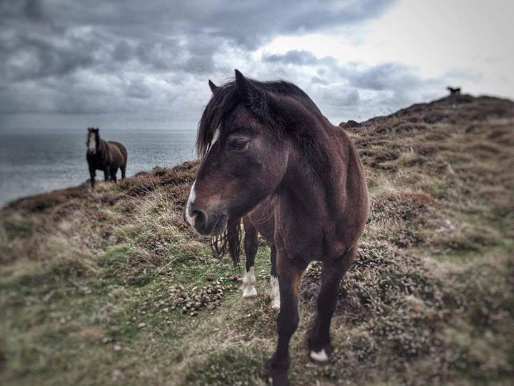
Nestled in the Carnedau mountains, with its rolling grassy mountain tops there is a remote feeling to these mountains compared to some of the other ranges in Snowdonia.
Overview of the Run
Llech Ddu spur sky running is engaging throughout and once on the tops of the Carneddau mountains the running is fantastic with unforgettable views across to Tryfan and the Glydderau. The descents are on wide easy angled grassy ridges allowing the spectacular scenery to be fully enjoyed while running.
18.3km (11.37 miles)
1024m
Moderate / 1
Approach
From multiple stops in Llanberis the S2 - Snowdon sherpa bus runs to Pen-Y-Pass. Change buses here to the S6 which runs to Bethesda during the summer months (April to October). It will be necessary to walk / run up Pen Y Bryn Road signposted “Ysgol Penybryn School”for 1km to reach the start.
Bethesda is reached by first travelling on the A4086 over Pen-y-pass from Llanberis. Turn left on the A498 towards Capel Curig and continue until you reach the T junction of the A5. Turn left signposted Bethesda and drive for 9.2 miles through the Ogwen Valley passing Idwal cottage and down the valley towards the Menai Straits. A short distance after the road sign for Bethesda turn right (opposite to the road leading to Zip World) and continue up through a residential area where the road is narrow at times.
After crossing over Afon Llafar continue on the rising road until you reach a T junction turning sharply right onto Gerlan road. At the bunkhouse, Caban Cysgu, park your car on the roadside being considerate of the locals.
There are no facilities at the start of the run as it is a residential area. The nearest public toilets are situated on Bethesda high street where a number of convenience stores, cafe’s, pubs and takeaways are situated.
Route Description
1.
From the bunkhouse head along Gerlan Road for 1km crossing over two rivers (Afon Gaseg and Afon Llafar). After the second take the track left (south) marked with a footpath sign. After 30 metres cross over the stile and keep to the left side of the field. At the top of the field climb the stile that crosses the wall and follow the path up right past old relics of enclosures and over a stream. This stream is followed on its left side to another stile.
2.
There is no obvious path after the stile and the ground is often boggy, aim for the centre of Cwm Pen-Llafar looking out for intermittent wooden posts guiding the way. After climbing a stile over a fence the path becomes obvious and well trodden following Afon Llafar towards the heart of the cwm.
3.
After 2.5 km a large pyramidal crag rises above Cwmglas Bach with a number of large boulders at its base. Head for the right hand side of the crag ascending a steep rock strewn grassy slope. A climbers path is soon obvious that traverses along the grassy ledge, underneath the overhanging crag. Ignore this though and continue on the path that zig zags up past the cliff until it is possible to traverse above it onto the shoulder.
4.
There are a number of rocky outcrops on the shoulder interspersed between the steep grassy sections, that can be linked together before the ridge becomes narrow and pronounced at 820m. The scrambling can feel exposed in places as the ridge is perched on top of steep grassy slopes but the rock is of excellent quality. Going direct over the ridge provides sublime scrambling with difficult sections being flanked on the left or right side, if required. After a final 6 metre steep rock step (avoided to the left) a faint path zig zags to the summit cairn of Carnedd Dafydd.
5.
From the summit head East initially passing cairns keeping to the edge of Cwmglas Mawr with breathtaking views to the South of Tryfan's North ridge and the Glyderau that should be savoured. At the Bwlch Cyfryw-drum contour on the right hand side around the two rocky outcrops before heading up to Carnedd Llywelyn. The summit plateau requires care with navigation in poor visibility as a number of faint paths lead in all directions, head North before veering in a North Easterly direction along the cliff edge past two prominent rocky outcrops. The path soon becomes obvious and wide ascending the grassy summit of Foel Grach.
6.
Descend in the direction of Carnedd Gwenllian, at the col the path splits into three. Take the left hand line contouring underneath the summit and continue contouring the subsidiary summits of Bera Bach and Drosgl. Eventually a large grassy plateau is reached and the path at this point splits, continue across the plateau in the same direction aiming between the twin crests of Gyrn Wigau. After a short descent cross the stiles over a wall and then a fence heading through swathes of bilberries and then the yellow coconut smelling gorse. The path descends to the right of a farm exclosure with a roofless building in it. Ignore the stile in front of you and take the track heading in a South East direction. The track soon becomes a road that leads to Gerlan Road, turn right to finish back at the Bunkhouse.
About this guide
Sky running is an extreme form of mountain running that includes using hands and feet (scrambling) to tackle technical terrain such as rocky ridges and ribs in breathtaking settings. Running in the mountains is an activity with a danger of personal injury. Participants in these activities should be aware of and accept these risks and be responsible for their own actions. If you don't feel you have the skills or experience for this route you should seek professional assistance.