Blog Post

Mountains of Mongolia

Dean Russell • Jan 13, 2023

“There is no reward without risk, I can’t imagine living without it” - Blaine Smith

Khuiten, Mongolia Mountain

Standing on the summit of Khuiten Uul, Mongolias highest mountain at 4,373m, breathing heavily after breaking trail through fresh powder on the upper slopes, I pause and take in the view of endless mountains stretching across China, Russia and Kyrgyzstan. As the sun heats my face and a gentle breeze brushes against my neck my mind wanders thinking about the fresh snow where I am stood, the journey its going to take, a journey through cycles of freeze / thaw, bonding itself to the snow pack. Through pressure and downward movement it will join the existing Pontanin glacier where it’s progress will slow, hundreds of years might pass as the elastic ice flows with gravities force down the valley before one day warming and melting, changing its form yet again and becoming a liquid that is so vital to sustaining life. It’s speed down the valley will accelerate past the vast plains and grassland steeps where grass and plants flourish, where livestock and nomadic families utilise it for survival, finding the path of least resistance and flowing past Ulgi, the regional capital of the Altai mountains where our journey began.


Flying into Ulgi at 1,700m in the extreme West of the country, the importance of the flowing Hobda river is all too apparent with the only green in the otherwise desert landscape within a few hundred metres of the river. Communities have long based themselves near water for obvious reasons especially in harsh environments and Ulgi, with its colourful tin roofs, has grown from an ethnic Kazakh village, before the founding of the modern nation of Mongolia in 1911, to a growing post communist city that is benefiting from a construction boom bringing many new apartments, restaurants, shops and hotels.


Our onward journey deeper into the West of the country was with a Russian UAZ van that is designed for dust roads and tough driving. The bumpy overland “roads” weaved along vast flood plains, over mountain passes adorned with blue prayer flags, for the sky gods, along grass steeps and glacial valleys following the river to the Altai range. Along the way we passed small ger (yurt) settlements, wild horses, camels, herds of yaks and workers cutting and storing the grass that will provide the feed for the animals during the long Mongolian winter.


Arriving at the local village at the head of the Tavn Bogd national park, we were welcomed by the elder of a small ger settlement. Wearing a traditional deel, worn since centuries ago, a colourful long jacket that is wrapped around the whole body made of cotton, the weathered man who’s age it would be hard to gauge with strong hands and an air of experience welcomed us into his family’s home. The gers are dark but cosy, simple but comfortable and a warm stove based at the centre is used for all the families cooking, utilising dried manure as the fuel in the absence of wood.  As is customary we were given delicious warm salted yak milk tea, fried flat breads and hardened milk curd, a favourite of small children for 1000’s of years.


Moving up to base camp (2,900m) involved a gently rising 16km walk alongside twin humped camels led by a local herdsman carrying our mountaineering and camping gear. We walk along the white river, named so as its waters stem from the glaciers above, transporting the water down to the communities below. The colours along the river had vivid autumnal hues that contrasted beautifully against the deep blue skies, grasses on the hillside turned yellow by the approaching winter with deep red pockets of Pallas (Rhodiola quadrifida) sweeping across the hills. We passed endless marmots as we ascended that whistled their altruistic warning cry to the madness of marmots in the area while black kites soared above hunting the beautiful playful ground squirrels that chase each other in pairs darting into their burrows when the shadow of the kites swept across the floor.  


Having gently acclimatised over the three days getting to base camp, a quick climb to an unnamed peak (3,884m) and with a good days weather forecast we decided to make an attempt on the three Saints surrounding the vast glacier, covered in deep scars caused my melt water and crevasses. Buried under the snow, the Tavn Bogd Mountains divide Russia, China and Mongolia with the highest peaks being known as the Saints which rise to above 4,000m.


Rousing from a deep sleep, putting on every layer to keep warm in the cold night, the first hours in temperatures below -15 degrees go by in a haze walking along the side of the huge moraines that describes where the glacier once sat. After an hour we started to rise over endless scree on the first mountain Manchinn. The darkness thankfully hid the route ahead which is a slog of 1,127m over broken rock until finally the first snow was illuminated by light coming from the East which coincided with us roping up.


Sunrise, the golden hour, alpenglow, that time when I feel so connected with the mountains and nature. The extreme darkness is first broken with faint hues of pinks appearing on distant ridge lines, as the earth rotates further these are followed by growing oranges and finally an intense gold as the sun appears on the horizon bringing much needed warmth to our feet and hands and our first Saint at 4,027m.  


We moved down the North West face, along a long snow and rock ridge towards the second Saint, Nairandal or friendship peak where you are able to stand in Russia, China and Mongolia at the same time.  With temperatures rising we kept the momentum going dropping back to the glacier instead of continuing along the ridge due to a huge cornice that looked ready to collapse along the intended route.  


After a short refuel we tackled the final peak of the day Khuiten Uul (4,374m), Mongolias highest mountain. Giving the large crevasses at the base of the face a wide berth before the mountain rears up with steep snow / ice for a coupe of hundred metres past 3 rock bands. With tiredness setting in we dug deep during the final summit push breaking trail through fresh powder with the affects of altitude all too obvious. Thin air means less oxygen is available to be absorbed into the bloodstream and the direct sun radiation from above and reflecting off the snow was uncomfortably warm and forced us to breath deep and take our time as we continued to our final summit, our final Saint. 


On that final top, after completing such a big traverse, we were tired and happy as we reflected on a shared experience in the mountains that will endure in the memory. Thinking about the snows quicker journey down to Ulgi than centuries before brought a degree of sorrow. In 24 years the view of the glacier stretching all the way back to basecamp will be no more and the ancient ice will be lost forever, lost to the sea adding to its ever rising level. The Pontaniin glacier is melting at a staggering five metres per year which has a knock on effect at a local level reducing the stability of river systems that communities in Mongolia rely on. Glaciers help to regulate water supply by storing precipitation in winter and releasing it in the summer, but as they melt away over the next couple of decades, more downstream areas will first experience a surplus of water, then a shortage that may well affect the nomadic lifestyle of many of the communities we passed.


In addition to the Khuiten traverse of the three saints (40km, 2,000m height gain, 3 x 4,000m peaks in 14 hours we traversed unnamed peak 3,884m (East to West) as acclimatisation and undertook a long East to West route from the glacier floor, taking unnamed peak (3,723) and along to Ulgii Burged (4,068m).


Dean is a Mountaineering and Climbing Instructor in North Wales and you can follow his adventures on instagram using the handle @adventure_awaits_uk

By Dean Russell 14 May, 2024
Hints and tips to enhance your technical running
By Dean Russell 01 Jan, 2024
Embrace the chill and discover a whole new satisfaction in your runs
By Dean Russell 05 Oct, 2023
How to ensure you have the best chance to complete this demanding and exhilarating hike.
Top runs in north wales; top runs in Snowdonia; running guiding; running snowdonia, sn
By Dean Russell 07 Nov, 2020
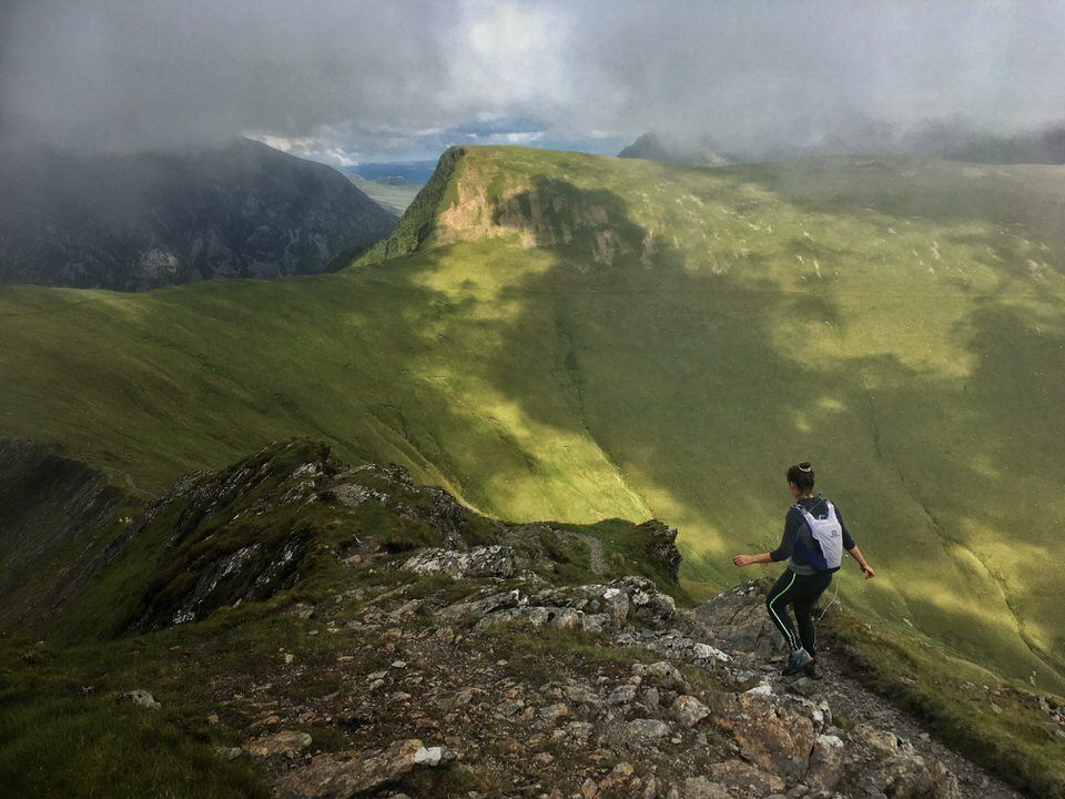
Second in a new series highlighting the finest running routes around Snowdonia's national park. In the second blog post the author, Dean Russell, showcases a short remote feeling run that packs a punch with a horseshoe run around the Northen mountains of the Carneddau.
By Dean Russell 27 Jul, 2020
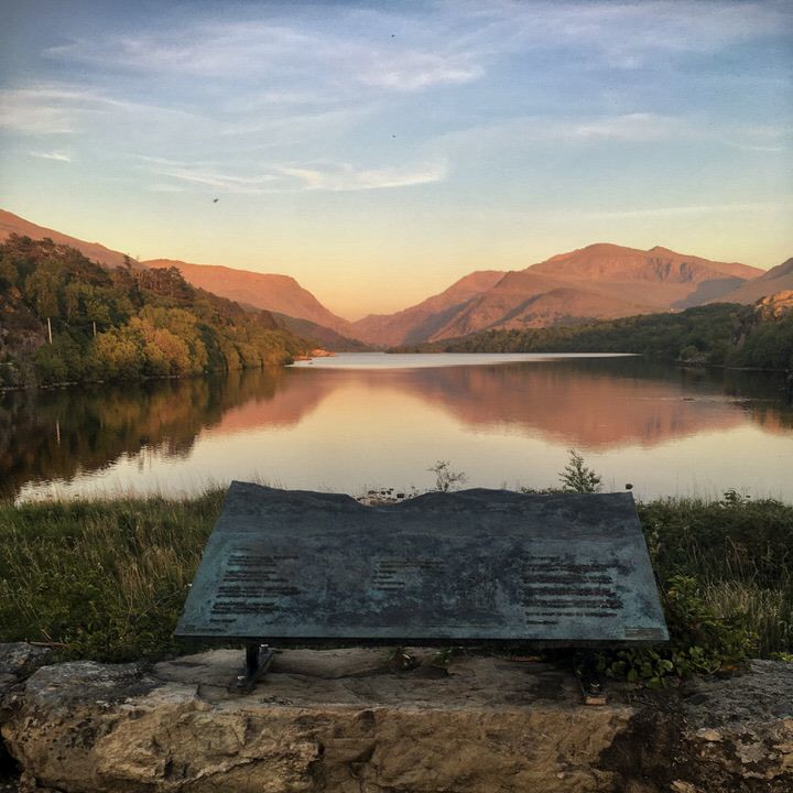
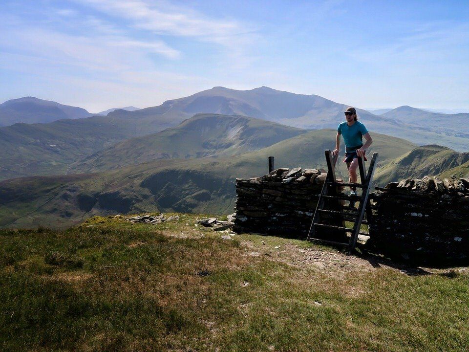
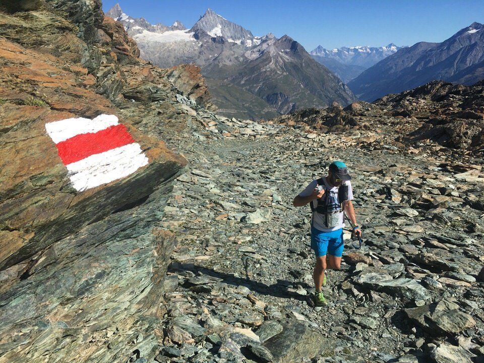
Many of us found ourselves with more time on our hands as lockdown and travel restrictions took grip and the country battled to contain the Coronavirus pandemic that spread across the world. Much of the National Park in Snowdonia closed to ensure there were no undue pressures on local emergency and rescue services and the beloved mountains were off limits for the time being. Running through lockdown was a good opportunity to gain an intimate knowledge of all the footpaths in the local area, often running through thickets of brambles and gorse on paths that had been long since forgotten. Living on the edge of Snowdonia National Park at the outlet of the glacially formed Llyn Padarn, many of my lockdown routes passed a brass plinth that speaks of the evolution of the scenery in front of your eyes. Many of my hours passed enjoying the mountains, reflecting so perfectly on the lake when the air was still, watching how the light morphed high up as the sun started setting on another day of lockdown. It was on one of these many nights that I started to trace the line of the skyline and imagined running a route from the end of the lake across all the mountain tops around Llyn Padarn. As many people delved into cookbooks, looking for the next bake, or updating general knowledge preparing for the next zoom quiz, I hunched over my kitchen table with the map of Snowdonia laid out tracing the same line I had envisioned earlier. What I had been tracing was the hydrological water catchment for Llyn Padarn, twelve peaks where rain drops run from its summits onto their rocky slopes, down steep runnels into streams and rivers feeding the lake, flowing right to the outlet where I had been admiring one of the best views in the National Park. With the levels of Coronavirus infections reducing, on another unusually fine Friday afternoon the news from the Welsh Government I had been waiting for was delivered in their regular briefing. The mountains were going to open in their entirety and it felt fitting to commemorate the opening by running the skyline that I had so often admired. To follow the water catchment the route first ascends gently on roads through the villages of Fachwen and Dinorwic and into the local quarries. Described by some as a blight on the landscape, the sometimes otherworldly looking vistas are a reminder of the industrial era when North Wales was home to one of the most important slate producing areas. Ascending through endless slate piles, up inclines, past buildings and metal work that once would of been integral to the workings you get a great sense of how hard and dangerous the work for the miners must have been. After leaving the quarries behind, already high in mountain terrain, the summit of Elidir Fach was soon under my feet. A further short pull brought the rocky summit of Elidir Fawr, with its jagged grey gritstone that is in contrast to the red sedimentary siltstone on the flanks leading to the summit. The hard work initially getting up high was rewarded heading along the spectacular ridge to Mynydd Perfedd and sublime views to Marchlyn Mawr reservoir, Ogwen valley and one of North Wales most iconic mountains, Tryfan. The position of the Glyderau with mountain ranges on either side gave a big mountain feel to the summits of Foel-goch and Y Garn before descending towards Twll Ddu, more commonly known as Devils Kitchen named due to the sinister plume of smoke rising from a huge crack in its cliffs. Instead of descending into the depths of the cauldron a steep ascent up scree slopes of Glyder Fawr was necessary which felt like traveling without moving as my feet slid from underneath me. Descent from the summit was via the red route that winds its way south through complex terrain passing boulders with a faint spray painted red dot leading the way. The views across the valley to the classically shaped Crib Goch were spectacular and left me in no doubt that the next section contains some of the best scrambling terrain in North Wales. Pen Y Pass was a welcome respite and a chance to grab a snack and recharge my batteries before the crux of the run. The going got tough as I made my way up from Pen y Pass with the technical, engaging scramble up the initially broad East ridge that converges to an airy ridge walk up to Crib Goch’s summit. The fun didn’t stop there though continuing along the summit ridge which has some spectacular positions where it is not uncommon to see people traversing it “Au Cheval” (like a horse) before yet more first class scrambling to reach the grassy summit of Crib y Ddysgl. The way forward was made up of skirting impressive Cwms that are the product of scouring in the late Ice Age that ended some 10,000 years ago. The geology of the Cwms are synonymous with glacial activity in Snowdonia with the mountains having two distinct faces, grassy slopes facing South-West and steep craggy ones facing North-East. After completing the technical section where my thoughts were solely on the next foothold and handhold as you traverse a couple of Snowdon’s giants its a welcome respite, even with tired legs, to run up and down the grassy summits of Moel Cynghorion, Foel Goch, Foel Gron and Moel Eilio. Appreciating the great views of the Nantlle valley and the Menai Straits, I found myself in a state with no thoughts running through my mind, no stresses, no to do lists, nothing. Running has long been associated with controlling stress and boosting the bodies ability to deal with mental tension. Combining that with the benefits of being in the mountains has long been vital to my own mental wellbeing and as I continued my run I could feel the mountains cleansing my mind with every step, oh how I had missed the mountains. Running down from Moel Eilio skirting another set of slate quarries the final summit of Cefn Du was soon arrived at with the sudden realisation that there are no well worn paths from its summit and so a degree of heather bashing was required. Following a faint path by a dry stone wall led to a better trodden path that drops down eventually to the main road and a short run back to the plinth where the journey had started. An opportunity to admire the views, a chance to reflect, taking in all the mountains that have been traversed and ponder there long evolution just as the words by Gillian Clarke describes: But for how long? Cherish these mountains, born in fire and ash out of the sea to make this wilderness, Asleep for aeons beneath ice and snow, carved by the shifting glaciers long ago, Till ten millennia back, the last ice age made right for fern and purple saxifrage, This place, whose evolutions given birth to the rare Snowdon lilly’s home on earth, But all could go with the melting snow. The Llyn Padarn Skyline is a 36 km run with 3,108m of height gain that was completed on the 6th July 2020 in 6 hrs 31mins and 25 secs. If you would like to have a go at the Skyline there are more details on how you can get your time recorded here . Dean Russell is an active trail runner, climber, mountaineer and trekker with over 16 years experience in the mountains. Usually found running and climbing in his local mountains in North Wales he offers private and group guiding highlighting the best routes in Snowdonia’s national park. If you would like further details then you can contact Dean here .
Top runs in north wales; top runs in Snowdonia; running guiding; running snowdonia, snowdon runs
By Dean Russell 19 Jun, 2020
First in a new series highlighting the finest running routes around Snowdonia's national park. In the first blog post the author, Dean Russell, showcases a run with some of the best views in the local area with a horseshoe run around Moel Eilio.
Running shoes, running adventures, running in north wales
By Dean Russell 31 Mar, 2020
Blog for those addicted to running with tips and ideas to help get them through the Coronavirus lockdown
Multi Day Running Trail Running Multi day events
By Dean Russell 14 Jan, 2020
Run some of the UK's long distance trails or traverse a mountain range in the Alps over multiple days for a new adventure in 2020 - here's some top tips on how.
Skyrunning Scree Running Lake View Adventure Awaits
By Dean Russell 19 Oct, 2019
Take your running to the next level and experience spectacular scenery, ridges and mountain landscapes that few runners ever encounter with this guide to the dark art of skyrunning.
Dennis Rankin Round Fell Running SkyRunning Adventure Awaits
By Dean Russell 04 Jun, 2019
An account of the gruelling 90km and 6,000m height gain fell running round in Northern Ireland
More Posts
Share by: